St. Mark’s Summit is a peak in Cypress Provincial Park, located along the Howe Sounds Crest Trail that towers above the Sea to Sky Highway and offers – surprise! – breathtaking views of Howe Sound. If you’re looking for hikes that are easily accessible from Vancouver, have moderate difficulty and incredible panoramic views, you’ll love this one. So does the rest of Vancouver.
Being such an ideal candidate for a Vancouver day trip, the St. Mark’s Summit hike is busy on weekends and extremely busy on summer weekends. It could mean that lines form in single file areas, and fellow hikers will be ahead of you and behind you at most times. Who to blame though? It’s still one of the best Vancouver hikes – actually, it’s among our favorite hikes in British Columbia. It offers unforgettable views without too much effort.
More wonderful hiking trails near Vancouver:
Hiking to Saint Marks Summit in Cypress Provincial Park
Directions to Cypress Provincial Park & parking

From Downtown Vancouver, take the Trans-Canada Highway towards Whistler, then take Exit 8 (Cypress Bowl Road exit). Follow the road towards the Cypress Mountain Ski Resort.
The trailhead is at the ski resort on Cypress Mountain. There’s a large parking lot next to the Cypress Creek Day Lodge and also in front of the Black Mountain Lodge. If it’s not enough, there are several more large overflow parking areas along the road. It’s one of those places in Metro Vancouver where parking is not a problem even on the busiest summer days.
Note: There are parking restrictions during winter when the ski resort is in operation, but St Mark’s Summit Trail is a summer season hike, and all parking lots are free in the summer.
If you plan to camp along Howe Sound Crest Trail, use parking lot 3B. This is the only one where you are allowed to park overnight.
Hike on the Howe Sound Crest Trail
Once you are parked, walk to the Cypress Creek Day Lodge (where you see the Olympic rings), because the trail starts past the lodge. There’s a junction with markers, and you need to follow the Howe Sound Crest Trail, marked with square, orange markers. They will take you all the way to the summit.

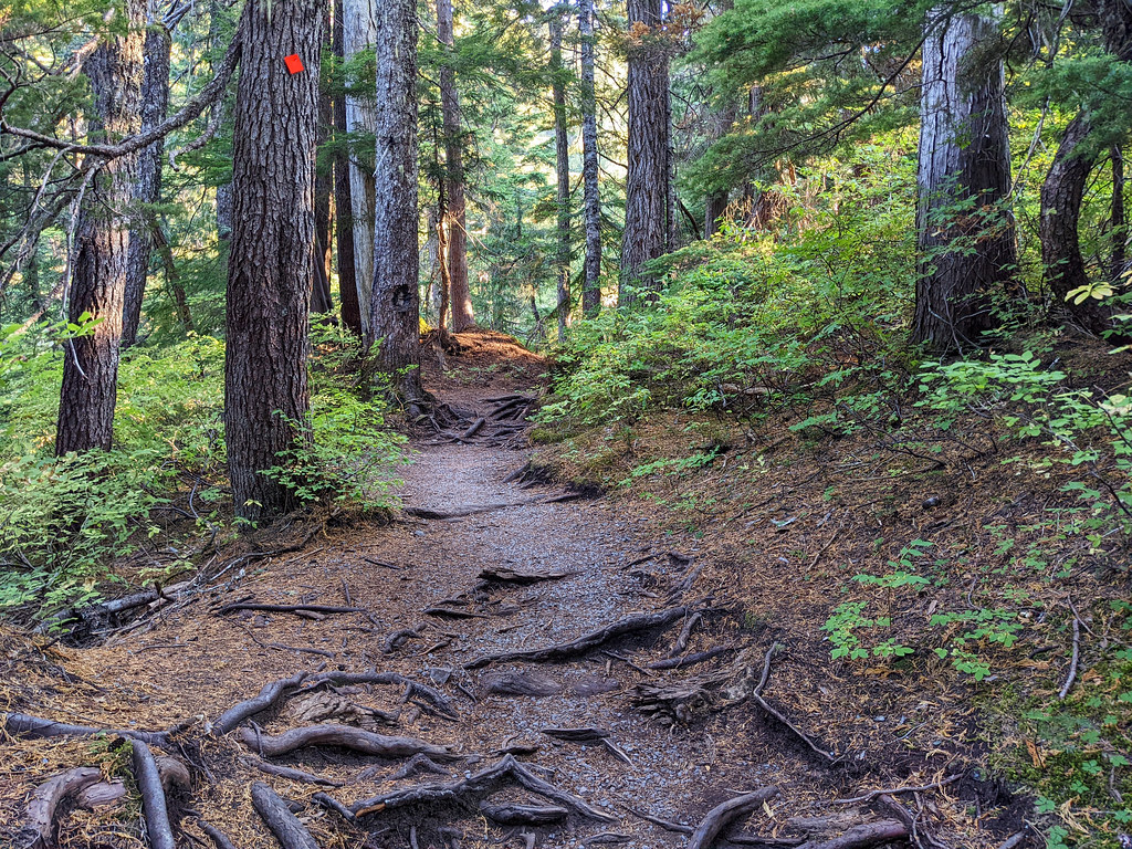
The trail starts in the forest, but you’ll soon pass along the left-hand side of a ski run. Just follow the orange markers, the path is obvious. (You can likely follow other hikers, as well.) This first section of the hike is steadily ascending in the forest, and it’s quite easy.
You’ll reach a junction at a large green water tower where you can choose between the Howe Sound Crest Trail West or Howe Sound Crest Trail East. They’re similar and they join after a while, but the West Trail allows a short detour to the Bowen Lookout. It’s worth doing it either on your way up or down. We usually keep it for the return hike.
The two trails join at a junction with a Cypress Provincial Park map. You’ll soon reach a meadow with a tiny bridge over Montizambert Creek after that. (There’s a side trail to Mount Strachan right after the bridge. It’s another fabulous Cypress Mountain hike.)
Reaching St. Marks Summit

After leaving the bridge, you get to the steepest section of the trail. The terrain gets more technical, with large roots and rocks. Finding footing is not always obvious, especially if the trail is very muddy (which it often is). There’s no real exposure, but be careful not to slip on the mud while tackling the steep switchbacks.
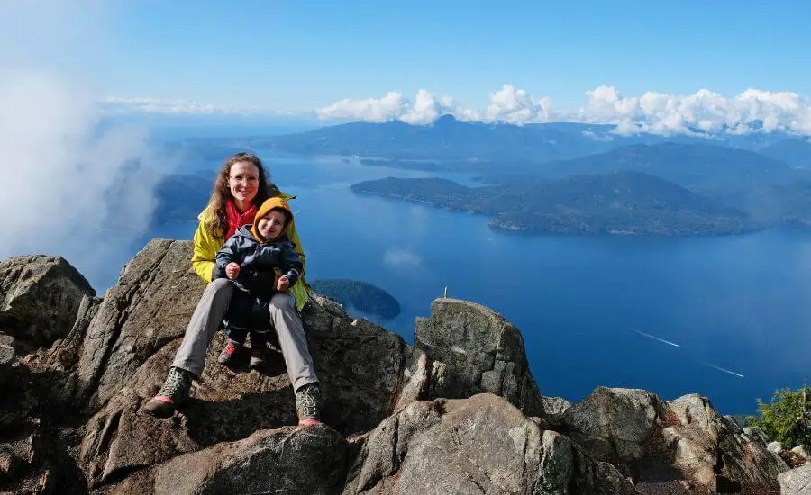
There’s a sign that marks the summit, and from there it’s a short scramble up the rocks on your left to reach the actual viewpoint and enjoy that incredible scenery: views of the islands of Howe Sound, the Tantalus Range and even Vancouver Island. But it’s not even the best viewpoint, at least in my opinion.

You’ll notice a rocky outcrop on your right, and you can navigate there on an official or several unofficial trails. It offers a different perspective, and it’s usually less crowded than the first viewpoint. Views of Horseshoe Bay and the Sea to Sky Highway down there are better from this viewpoint.
Finally, you return back on the same route, not counting the West Trail with the optional detour to Bowen Lookout.
Hiking essentials:
- Trailhead: Cypress Creek Day Lodge
- Length: 11.5 km return
- Elevation gain: 580 m
- Difficulty: moderate
- Season: July – October
- See the trail map here!
How hard is the St. Marks Summit hike?

You drive most of the elevation, so it’s not a difficult summit. The ~580 meters elevation gain in 5.5 km is still to be conquered, it’s neither an easy nor a short trail. But it’s well-maintained and all in all a moderate hike for most people. The last stretch can be more challenging, especially in muddy conditions.
You see many kids on the trail, though it’s definitely not for the youngest ones. We did it with 2.5-year-old Tomi, but Csaba carried him for most of the way.
Which is the best time to hike to St. Marks Summit?

moderately muddy conditions in October
It’s located high enough that it gets plenty of snow each winter, and it won’t melt until early or mid-summer. It’s safe to say that you can do the St. Mark’s Summit hike between July and October in general. But it’s one of those Vancouver hikes where the actual hiking season varies based on weather conditions in the current year.
After a warm spring, you might do it in May or early June, but if it still gets fresh snow in May, the beginning of the hiking season likely shifts to July. However, if you do it right after snowmelt, prepare for a LOT of mud! Our favorite time to hike is late September or October when summer crowds have thinned out and mosquitoes died. But expect plenty of mud even then, especially after heavy rains.
Unlike some other hiking trails in Cypress Provincial Parks, the St. Mark’s Summit trail is not recommended for winter hiking due to extreme avalanche risk.
4 useful tips before you hit the St. Marks Summit Trail
Be aware of how to hike safely in bear country and carry bear spray. Black bears are often spotted on higher elevation North Vancouver hikes.
If you hike in the summer, hike early morning or mid-week to avoid crowds as much as possible.
Proper hiking shoes are a must on this trail, and we recommend waterproof hiking boots, because it’s almost always very muddy.
The trailhead is not accessible by public transport. You can hike up to the Cypress Mountain resort from North Vancouver, but it adds much more length and elevation gain to the hike.
Alternative trails

On your way to the summit or back, there’s another detour option which adds some length but not much elevation gain: a detour to Yew Lake. It’s not an alpine lake, but still lovely, along with the surrounding small ponds on the subalpine meadows.
Also, the trail doesn’t end at St Mark’s Summit. You can continue northward on the Howe Sound Crest Trail to Unnecessary Mountain or The Lions. Hiking the entire length of the Howe Sound Crest Trail is more than a day hike though. It’s 29 km, stretching from Cypress Bowl to Porteau Cove.
Other scenic hiking trails in Cypress Provincial Park

view from Mount Strachan
Mount Strachan is less than 8 km altogether, though it has quite some steep sections. The trail follows the Howe Sound Crest Trail for a while, but after the junction, it gets significantly less traffic. The summit area is large and much less crowded than St Mark’s Summit, even though it offers similarly spectacular views.
Eagleridge Bluffs via Black Mountain Trail is a 8.9 km return hike that passes several small lakes and offers impressive views of Vancouver and part of the Horseshoe Bay at the end. It’s a year-round trail, but microspikes are recommended during winter.
Hollyburn Peak is a 6.5 km return trail, the easiest scenic winter trail in Cypress Provincial Park.