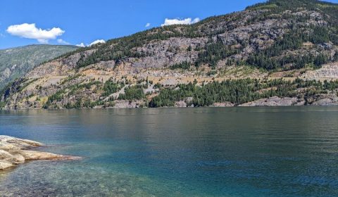
Blanket Creek Provincial Park became one of our favorite places to camp in British Columbia. One of our favorite places to be with a kid, too. With a small, pleasant and beautiful swimming lagoon, several short waterfall walks, a well-equipped campground and the proximity of Revelstoke and Mount Revelstoke National Park, it’s an ideal place for outdoorsy families.
It’s one of the four provincial parks on the Arrow Lake Reservoir, one not too well-known by visitors and beloved among locals.
I can’t wait to tell you all about the things we enjoyed there, so I won’t. 😛
Don’t just visit BC. Experience it.
Discover BC’s hidden gems and breathtaking routes without the planning headache. Your perfect road trip is just a click away.
What to do at Blanket Creek Provincial Park?
Camp in Blanket Creek Provincial Park
First thing first: you have to try out camping! We loved the campgrounds in the provincial parks of British Columbia in general, but some were more memorable than the others. The one in Blanket Creek park was one of those especially memorable ones.
We were able to book a campsite a few months ahead, as a start. It’s an advantage, in case you’re wondering. The provincial park and national park campgrounds in BC are super busy. Many of them fill up a few minutes after the booking system opens for a certain period. Blanket Creek was a joyful exception (at least a summer ago). Otherwise, frontcountry campsite reservations can be made up to four months in advance of your arrival date – and I highly recommend making them as soon as you can. If you can’t find an available spot for your dates, you might try the search with flexible dates.
Once you have a campsite booked, you only need to come and enjoy it. The campsites are well-separated inside the forest, and most of them offer enough privacy. They all have benches, too, and (unlike in the Canadian Rockies) they won’t be frost-kissed by the morning in the summertime.
You might need mosquito nets or spray in the summer though. We found there were a ton of hungry mosquitoes around the campsite even in August. It’s a bit different from year to year though, depending on spring snowmelt. If you’re lucky, the mosquitos will be dead by late summer.
The campground has excellent amenities. In addition to the basics (toilets and drinking water), there are hot showers and flush toilets for guests. The flush washroom is quite new and very nice.
Then there’s a lovely playground and a warm, man-made lagoon for swimming, both just a few minutes walk from the campsites (maybe 10 minutes if you’re on the opposite side). You enjoy nice mountain views from the sandy shores of this lovely lagoon. Then you can launch your canoe or kayak close to the beach area on the Arrow Lake Reservoir, and you find short walking paths in the forest and along the reservoir.
5 essential things to pack for tent camping in British Columbia
Lightweight tarp (two of them, actually): shelter from the rain, shade from the sun and an extra layer under your tent. It can rain any time of the year, and tarps kept us (and our tent) dry during so many downpours. Nothing fancy, just a simple, lightweight tarp – and a…
Paracord: to fix the tarp and to solve a million other problems. Really, paracords are versatile and come handy in so many situations while camping. Have a spare one, keep it in the trunk of your car.
Mosquito repellent: the mosquitoes in some areas of BC can be vicious, especially in spring and early summer. Use a repellent spray, mosquito patches or a mosquito head net (or all of them).
Lighting: always, always bring a separate source of light (and I don’t mean your phone). If your hands can be free, it’s ideal: headlamps and/or lanterns. A lantern is great for hanging out by the fire or lighting up the tent for evening card plays.
Camping stove: don’t rely solely on campfires for cooking food. Campfire bans can come in at any time, or the wood might be too wet. Bring a classic propane stove, extra points if it has wind-blocking panels.
It’s easy to spend quite a few pleasant summer days only inside the campground, swimming, splashing, paddleboarding or kayaking. Or walking to Sutherland Falls…
Walk to Sutherland Falls
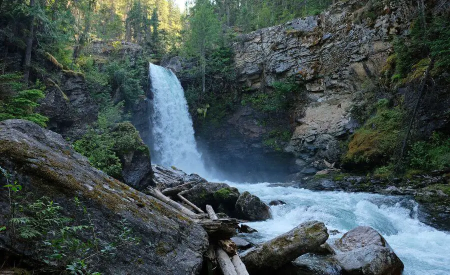
Sutherland Falls is a glacier fed waterfall, dropping 14 meters and roaring in the summer. It’s such a short walk, a 0.5 km round-trip from the roadside parking area, yet it’s one of the most impressive waterfalls in the Revelstoke area. It offers an amazing reward for very little effort.
It’s located in Blanket Creek Provincial Park, just off Highway 23, but it’s ahead of the campground a bit. So you either walk about 1.5 km (there and back) from the campground, or drive to the parking area. The trailhead is clearly signed, and it only takes a few minutes to reach the beautiful waterfall.
Any kid could complete the trail – and if not, anyone can carry their kid to the waterfall. You can cautiously get down to the creek and have some water play. It really depends on the water level though, and I’d keep kids within arms reach all the time when you’re close to the water.
Find Begbie Falls
Begbie Falls is a 12 meters high pretty double waterfall at the mouth of Begbie Creek on the Upper Arrow Lake. It’s surrounded by mossy cliffs and a fabulous forest.
Begbie Falls is a 20-minute drive from the Blanket Creek campground, and the trail starts from a day use area at the end of the Begbie Falls Forest Service Road. It’s only 400 meters one-way on a forest trail which is rough and a bit steep at times, but this only makes it more exciting for kids!
Begbie Falls hike:
- Trailhead: the end of the Begbie Falls Forest Service Road
- Length: 400 m one-way
- Difficulty: easy
- See it on a map here!
Wait, forest service road?! Yes, the last 2 kilometers of the road to this trailhead is on a dirt road. Even though forest service roads are known for being suitable mainly for high clearance and 4WD vehicles, we found that this one is okay with a low clearance car, too. The trail starts from the signpost, and a few switchbacks take you down to the falls.
However, if you don’t want to drive on a forest service road, you can still get to Begbie Falls, only you need to walk more. Use the Begbie Bluffs Parking area on Highway 23 and hike on the Bluff Trail. It’s 2 km one-way, see the exact route here.
If you’re in search of low cost camping, Begbie Falls Recreation Site offers 26 camping spots. They’re quite off the busy tourist path, reachable on a first service road. As it’s usually the case with recreation sites, the campground is tranquil, but very basic (only tables and toilets, no water!). Please make sure to leave it as you found it, take your rubbish with you.
Enjoy views from the Big Eddy Bluff (or Boulder Mountain Lookout) in Revelstoke
The Big Eddy Bluff Trail is a local gem, maintained by volunteers, and oh, wow, what an incredible view it offers! It’s a view of Revelstoke, the Columbia River zig-zagging through it and all the surrounding mountains, snow-capped until early summer. It’s also called Boulder Mountain Lookout (and that’s how it’s marked on Google Maps).
Revelstoke is only about 30 minutes drive from Blanket Creek Provincial Park, and you can find a few tempting short hikes in and around this small town. Those hikes are actually the reason to visit Revelstoke – well, and the ski slopes and nearby Mount Revelstoke National Park.
Hiking essentials:
- Trailhead: pullout along Westside Road, right before Jordan River – see the exact spot on the map
- Length: 2.9 km return
- Difficulty: medium
- See it on the map here.
The trailhead is just outside of Revelstoke, off Highway 1. As you turn north onto Westside Road, park your car before you cross the Jordan River. There’s no official parking lot, but there’s an area where several cars can pull over (and you’ll likely see other cars). If you pass the Jordan River bridge, you’ve gone too far.
The trail starts on the west side of the road, and it’s generally easy to follow. It can get very muddy, and there’s one short section which is a bit challenging. It’s a small wall that you reach after a few minutes, and you need to “climb” it with the help of a few ropes. (These few steps are the reason I consider this hike “medium”, otherwise it’s quite short and easy. But it’s nothing to worry about, there’s no exposure, you just need to pull yourself up a bit with your hands.) Then it’s a steady uphill to the viewpoint on the well-marked trail.
It’s at a relatively low elevation, so this trail should be snow free between May and October.
Take the steep path down to Moses Creek Falls
A very short, quite steep, somewhat technical and not really maintained trail takes you down to Moses Creek Falls – which is such a lovely one! British Columbia is full of such amazing waterfalls, and no matter how many we found, we never wanted to skip another one.
I admit that getting down to Moses Creek Falls was a bit of a hassle with a toddler, because this short trail (that I marked here) is quite technical, but we managed it. And it was worth it. Once you reach the first cascade, make sure you continue down to the second set of falls, then further down to the Columbia River, as well.
Depending on recent rainfall, it can be muddy and slippery. No matter how short it is, you need proper hiking boots with a good grip on this terrain.
Walk the Greenbelt Path along the Columbia River in Revelstoke
So the Columbia River turns into a series of long lakes in this area. Beautiful, calm and quiet. Like the sleepy mountain town of Revelstoke. If you’d like to take a walk in town, one of the coffee shops is a suitable destination (there’s definitely not many sights in Revelstoke), but I have an even better idea: the Greenbelt Path!
This walk treats you with views of the valley, mountains, maybe wildlife (yes, maybe even bears!). It’s flat, easy and peaceful. I call it a walk, because it is. If I lived in Revelstoke, this walk along the Columbia River would be my favorite afternoon stroll.
The walk has several access points. We started from Centennial Park. It’s about 4 km return, and you’ll be parallel with the river for almost all the way.
Drive the Meadows in the Sky Parkway scenic drive
The Meadows in the Sky Parkway is a 26 km scenic drive in Mount Revelstoke National Park. It starts just outside of Revelstoke, and you can reach it in 30 minutes from the Blanket Creek campground by car.
Mount Revelstoke is one of those few mountains in British Columbia where you can drive to the top, almost all the way to the top. You start at an elevation of 470 meters on the Trans Canada Highway and get up to 1835 meters at Balsam Lake. You found lots of viewpoints along the way, most of them only a few steps away from the road. Finally, the 1 km long Upper Summit trail takes you to the actual summit from the end of the road (the Balsam Lake parking area).
Here are the viewpoints that have names:
- Revelstoke viewpoint
- Monashee viewpoint
- Columbia viewpoint
- Eagle Pass
- Bridge Creek
- Panorama Point
- Balsam Lake (at the end)
But what about the nameless stops? We were amazed by the wonderful wildflowers along the road, and it’s worth stopping to take a closer look and some nice pictures (if you can find a safe pullout). The scenic drive got its name after the subalpine wildflower meadows.
Best time to visit Blanket Creek Provincial Park
First of all, Blanket Creek campground (and the car park) is closed in the off-season, which is roughly between October and April. While Revelstoke is a good skiing destination in the winter, it’s the summer season when you can enjoy swimming, paddling and hiking in Blanket Creek Provincial Park and in the Revelstoke area.
There’s no ideal time to visit. June might be a bit too early for higher elevations (or if you plan to continue to other, higher elevations elsewhere in the Kootenay). July might be the worst for mosquitos. August might bring wildfires. From another viewpoint, any time in the summer might be pleasant to visit. I’d visit in early August – and would bring plenty of mosquito repellent.
Overwhelmed by BC trip planning?
Relax. We’ve handled all the details. Get your easy-to-follow guide and start your unforgettable adventure.
