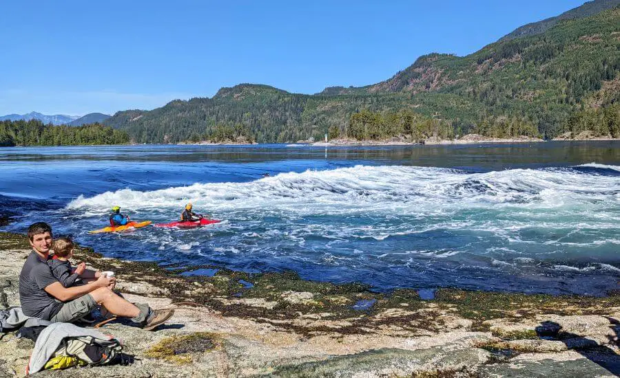
The Skookumchuck Narrows hike was among our favorites on the Sunshine Coast of British Columbia. It’s a “whitewater wonder” like no other. Twice every day you can marvel at powerful rapids and whirlpools as the tide changes, the flow of saltwater switches, and it reverses the direction and power of the Sechelt Rapids.
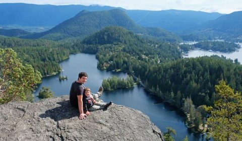
The hike to Skookumchuck Narrows is easy (and popular!), and it leads through a typical, beautiful West Coast rainforest. Finally, it ends on the coast, and there are two different viewing areas. In this post we collected everything you need to know before you visit (and we’re determined to convince you to do so – do we really need to?). It’s certainly one of the most unique natural attractions on the Sunshine Coast.
BC Trip Planning is Overwhelming. So We Did It For You.
Our compact guide delivers step-by-step itineraries to BC’s best sights and hidden gems.
What exactly are the Skookumchuck Narrows?

The Skookumchuck Narrows near Egmont are part of the Skookumchuck Narrows Provincial Park. What does this strange name mean? First of all, it’s Chinook Jargon, and “skookum” means powerful, while “chuck” means water. The Skookumchuck Narrows are one of the largest tidal flows in the world!
Nature puts on a spectacular show twice each day as the tide changes. The inlet is big, but the opening to the inlet is narrow, so the result is: when the tide changes, a huge volume of water rushes through the narrows, the flow of saltwater switches, reversing the direction and power of the Sechelt Rapids, and forming whirlpools and rapids.
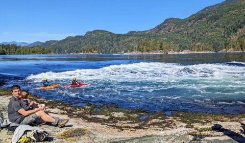
How powerful are these rapids? The water can flow as fast as 33 km per hour! But speed is not the only impressive thing here: the water level can be up to 2 meters higher on one side of the rapids than the other. You simply stand there, watching them in awe.
Whitewater kayakers and surfers also like playing in the rapids during flood tides, and they’re a fun sight, too.
The Skookumchuck Narrows trail

You can reach the spectacular rapids on an easy 4 km hike in Skookumchuck Narrows Provincial Park, located near Egmont. The trail is well-developed and has minimal elevation change. At the end, you’ll be rewarded with views of one of the largest and most powerful tidal flows in the world – if you arrive at the right time, that’s crucial.
The tidal patterns keep the water moving in this area, which results in a rich sea life. We were impressed by the underwater world, even without going into the water. We saw a kelp forest while venturing out onto the coastal rocks in the sheltered bay, and also countless sea stars and anemones under the water.
Skookumchuck Narrows hiking information:
- Distance: 8 km return
- Elevation gain: 90 m
- Difficulty: easy
- Hiking season: all year
- See the Skookumchuck Narrows trail map here.
How to get to the Skookumchuck Narrows trailhead?
From Vancouver you need a ferry to reach the Sunshine Coast: the ferry from Horseshoe Bay to Langdale. Then drive towards Sechelt, and head north on the Sunshine Coast Highway. Before you reach Earls Cove, turn right onto Egmont Road towards Egmont.

The “Egmont Heritage Centre Museum” is a good direction for navigation. You’ll notice the Skookumchuck Narrows Provincial Park sign on the right side of the road, with lots of angle parking on the gravel shoulder. The Egmont Heritage Centre Museum also offers a parking area. Don’t drive further on Doriston Highway to the Skookumchuck Narrows Trailhead, because you won’t be able to park there.
Don’t just visit BC. Experience it.
Discover BC’s hidden gems and breathtaking routes without the planning headache. Your perfect road trip is just a click away.
Skookumchuck Narrows hiking guide
Doriston Highway is actually a gravel road where it’s lovely to walk. You’ll cross a bridge, then pass by the Skookumchuck Bakery and Cafe. It’s open from spring through fall, and they have delicious homemade baked goods, sandwiches and coffee. It’s a nice place to take a break after the hike.
Finally, Doriston Highway ends at the Skookumchuck Narrows Trailhead. There’s a large turn-around area and countless “no parking” signs, and a wide, quite flat trail starts in the forest right in front of you. It’s an old logging road, and takes you through the amazing West Coast rainforest, with lots of ferns, moss and huge cedar trees.

After about 2 km you’ll pass Brown Lake. It has pretty reflections on a calm day. Then you’ll start getting closer to the coast, and you’ll notice a few ups and downs.
There are two viewpoints on the coast, and you can reach them on separate paths. The junction for North Point is at about 3.5 km. This is the best viewpoint for whirlpools on an ebb tide. The viewing area is on a wide rocky bluff, which is fenced, and there are some benches.
Roland Point is further straight from the intersection, and it’s the best for rapids on a flood tide. This last section of the trail is rough, with lots of roots, rocks and uneven sections. It descends to sea level, and Roland Point is a rock outcropping right by the water’s edge. This is the place to look for sea stars and anemones below the surface.

It’s an out-and-back route, so you take the same path back. There’s a toilet at the Egmont Heritage Centre Museum, and there’s an outhouse near the North Point viewpoint.
Where to stay on the Sunshine Coast?
- Rockwater Secret Cove Resort in Halfmoon Bay (beachfront resort)
- Bonniebrook Lodge in Gibsons (beachfront wooden lodge)
- Sunshine Coast Resort in Madeira Park (4-star beachfront resort)
The best time to hike to Skookumchuck Narrows
Timing is crucial to see the rapids and whirlpools at Skookumchuck Narrows. You can only see them when the tide changes and the flow of water switches directions.
Check a tide table to calculate the correct time between high and low tides (see the Skookumchuck Narrows tides here). Here you find the Skookumchuck Narrows tide times calculated for 2023 by the Sunshine Coast Tourism, making it easy to find the best viewing times. The big waves can be seen from Roland Point when there’s “Flood Current (+)”. The whirlpools can be seen from North Point when there’s “Ebb Current (–)”.

Though there’s a specific peak to each tide, there’s a 20-30 minute window of viewing opportunity spanning on each side of the peak. If you’d like to enjoy the beautiful landscape without many people, hang back after the peak time. Most people head back right after the peak, so you can have both viewpoints for yourselves if you wait a bit.
If the best time to see the Skookumchuck rapids or whirlpools are very early or late in the day, don’t forget to bring a flashlight or headlamp.
Leave a Reply