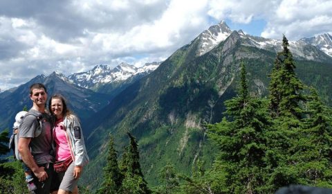
The Iceline Trail is one of our favorite hiking trails in British Columbia. With astonishing alpine landscapes, rocky peaks, glaciers and dramatic valley views, alpine lakes and waterfalls, it’s a feast for the eyes and is among the most scenic high mountain trails we’ve ever done (which is saying something since we hike a lot). It’s located in Yoho National Park, which is about an hour’s drive from Banff, so it’s easy to include in your Canadian Rockies road trip itinerary.
It makes for a nice addition when visiting Banff National Park and Jasper National Park, both of which are much busier than Yoho. It also makes for a great day trip from Lake Louise.
This post is your detailed guide to the Iceline Trail hike, with everything you need to know before setting foot on the trail.
Best accommodations for Yoho National Park:
- Luxury: Emerald Lake Lodge (Yoho National Park)
- Mid-range: Canadian Rockies Inn (adults only, located in Field)
- Budget: camping 🙂
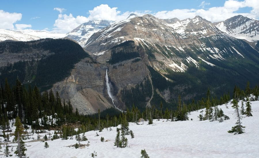
The Yoho Valley and the 373-meter (1,223 feet) high Takakkaw Falls are fairy tale destinations, we recommend visiting this area even if you don’t have time to complete the Iceline Trail. You can walk to Takakkaw Falls, enjoy a riverside picnic and the scenic drive through Yoho Valley.
BC Trip Planning is Overwhelming. So We Did It For You.
Our compact guide delivers step-by-step itineraries to BC’s best sights and hidden gems.
Iceline Trail hiking guide
So let’s see the details of the Iceline hike, the most popular of the Yoho National Park hiking trails. You can either do it as a 20 km long full day loop hike, a 14km long out-and-back hike, or make it part of a multi-day backcountry camping trip.
Trailhead: Takakkaw Falls parking lot
Drive to the Takakkaw Falls parking lot on Yoho Valley Road. This drive is quite spectacular, with views of the wild mountain landscape, but it has several narrow switchbacks, so the last stretch of the route is not suitable for motorhomes.
The parking lot is likely to be busy, but it’s large, too. If you hike the loop, it doesn’t really matter where you park. If you’re planning an out-and-back hike, try to park in the south, because that’s where the trailhead is. For a backpacking adventure, the north end of the parking lot is the most convenient. In that case you’d begin with the other end of the loop, aiming for Laughing Falls Campground, or you can simply walk to the Takakkaw Falls Campground (walk-in tent sites). Or maybe you’ll be happy to find a spot anywhere. 🙂

Follow the paved path along the river, the same way which takes you close to Takakkaw Falls. That’s a worthwhile detour, but I’d keep it for the end of the hike. Now you’ll walk past the wooden bridge, and follow the path that bends to the right.
Hiking up to the alpine
Hike towards the Yoho Valley Road (this is the road you drove on the way in), then cross it, and go past the HI Yoho Hostel (or “Whiskey Jack Hostel”). The switchbacks start after that: the trail takes you into the forest and heads up steeply, through a series of steep switchbacks. This section is the steepest on the Iceline hike and it lasts for roughly 3 kilometers. There’s a side trail that branches to the left towards the Hidden Lakes. It’s a short detour, so we did it, but it’s not really worth it. The “hidden lakes” are rather two muddy ponds, and they are nothing compared to what comes on the Iceline Trail later on.
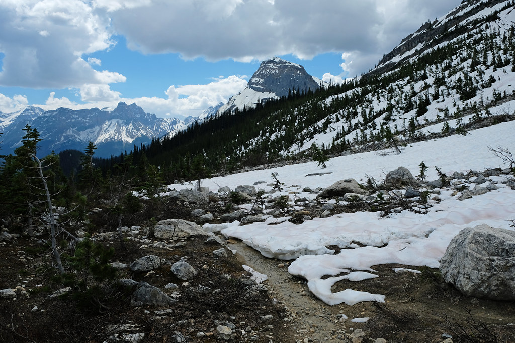
Once you conquer the switchbacks, the trail leaves the trees, and you find yourself in the beautiful alpine. The hike doesn’t cease to awe from this point on, the views are only getting better, and the path is very easy, almost flat.
Continue on the scenic ridge
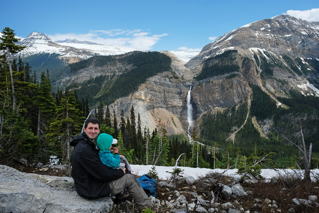
You can enjoy the sight of magnificent Takakkaw Falls spilling down the sheer rock face just across the valley, Daly Glacier above it, and snow-capped peaks all around you. It’s a high mountain landscape at its best.
The trail gets a bit more rugged and uneven at times as you cross debris left by the receding glaciers. It’s a ridge hike, with the typical amazing views, but without the exposure (you are exposed to the wind though). The weather can change suddenly, so make sure to pack extra layers and a windbreaker.
What to wear hiking in the summer?
Hiking pants, preferably zip-off pants: mornings and evenings are chilly, so you’ll be happy to wear long sleeve pants, but it’s very practical if you can simply zip the sleeves off in the hottest part of the day, or when hiking uphill. Columbia offers affordable, practical and durable models both for women and men.
Waterproof hiking boots: appropriate footwear is very important to have an enjoyable and safe hike. We recommend wearing hiking boots that provide good traction. Waterproofness is also important, because weather in BC is quite rainy for most of the year, and melting snow makes lots of trails muddy well into the summer. Dry feet are key for a happy hike. This Columbia Newton Ridge Plus is a great option for women, and the Newton Ridge Plus II for men.
Long sleeve hiking top: you can wear a lightweight, long sleeve top with sun protection as a standalone wear on high mountain trails (it never gets too hot up there, but the sun will be harsh on your skin on clear days), or you can use it as an additional layer when it gets chilly in the morning or evening at lower elevations. This BALEAF top for women offers UPF 50+ protection, and NAVISKIN has a long sleeve T-shirt with UPF 50+ protection for men.
T-shirt: moisture-wicking and quick-drying technical T-shirts are the best for hiking on a hot day. Here’s a great model for women, and here’s one for men.
Hiking socks: merino wool blends are moisture-wicking and breathable, they keep your feet cozy either when temperatures are warm or cold.
Waterproof rain jacket: a lightweight, easily packable rain jacket should always be in your backpack, just in case. You don’t want to get caught unprepared in a sudden storm. Columbia jackets are affordable and effective for the average hiker, here you find them for women and for men.
Out-and-back option of the Iceline hike
If you do this as a return hike, you can turn around as soon as you feel you enjoyed the views long enough, there’s no specific turnaround point. The second glacial lake on the way could be a good place to turn back though, because the views don’t change too much past that point.
You return to Takakkaw Falls parking lot the same way, but it’ll be much quicker since it’s all downhill.
Loop hike: Iceline Trail via Little Yoho Valley and Yoho Valley

We recommend hiking the full loop if you have the time and the stamina. The Celeste Lake Connector is branching to the right on the way, and you can make the loop shorter if you choose it. It descends through meadows and forest to the Yoho Valley, while passing Celeste Lake, of course.
But to complete the full loop, stick to the Iceline Trail, and enjoy those fantastic views for a bit longer. Pass a few more glacial lakes before the trail descends back into the forest. It remains in the trees for the rest of the hike, so you’ll have to say goodbye to those views on the ridge.
You’ll cross the rushing Little Yoho River and descend into Little Yoho Valley, passing ACC Hut and Little Yoho Campgrounds, as well. A series of switchbacks take you down to Laughing Falls and the Laughing Falls Campground. The hike is easy from there, running in Yoho Valley and crossing a few bridges, before you end up in the Takakkaw Falls parking lot.
Hiking essentials:
- Trailhead: Takakkaw Falls Parking Lot
- Length: 20.5 km loop (or 14 km return)
- Elevation gain: ~860 m
- Difficulty: medium
- See the Iceline Trail map here.
Take a detour to Takakkaw Falls
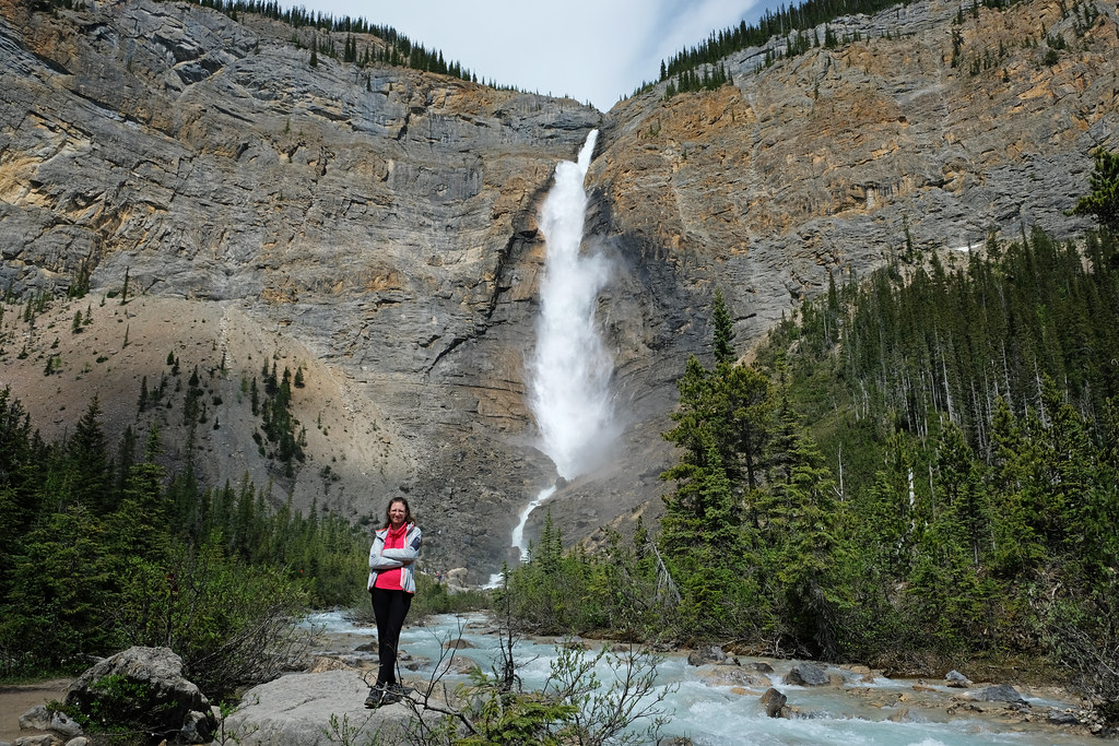
After you finish the Iceline trail hike, it’s worth taking the short stroll to Takakkaw Falls. It takes you over the river and to a closer viewpoint to admire this 373 meters high waterfall, one of the tallest single-drop waterfalls in Canada. It’s fed by the meltwater from Daly Glacier, and you can expect to be soaked from its spray as you get close.
We were struck how similar it is to California’s famous Yosemite Falls: the roaring waterfall and the giant, towering rock wall. The walk from the parking lot to the base of the falls is 1.4 km return. (See the route on a map here.)
Is it worth doing the Iceline loop via Little Yoho Valley Trail?
Yoho National Park’s Iceline Trail is amazing, either you hike the loop or the out-and-back option. We’d recommend the loop, then you won’t miss out on any of the scenery, nor on Laughing Falls which is not part of the hike if you return from the “Iceline summit”. I prefer loops to out-and-back routes, anyway. But it’s a long loop, take that into consideration, as well.
With that said, the out-and-back route has all the best views, and the scenery doesn’t change much later. Then you’d lose the views as you enter the forest, anyway. So if you don’t feel comfortable with the ~20 km distance, rest assured that the shorter out-and-back route is almost as fabulous, and will certainly impress!
How difficult is the Iceline Trail hike?

The Iceline Trail is one of the most popular hikes in Yoho National Park. Even though it requires stamina, it’s not a very difficult trail. There’s no exposure, no rock scrambling needed at any point. Most of the elevation is gained during that ~3 km of steep switchbacks during the first section of the hike. Once you’re in the alpine, it’s a slightly ascending terrain. But the length of the trail, especially the full loop, requires stamina.
If you don’t hike often in mountainous areas, you’ll likely find it difficult. Also, the trailhead sits at around 1500 meters, and the highest part of the trail is around 2150 meters. Hiking at such a high altitude is more tiring, because there’s less oxygen. Parks Canada rates it as a difficult trail, marked with a black diamond.
Proper hiking boots are definitely recommended. You’ll cross glacial debris, there can be patches of snow on the trail even in mid-summer, and the rocky terrain of the alpine is best explored in thick boots.
How much time do you need to hike the Iceline trail loop?
It really depends on your pace. But the out-and-back route typically takes 4-6 hours, while the full loop rather takes 6-9 hours. It’s certainly not a trail to rush through, because the views are to be savored. (And you’ll want to take thousands of pictures.)
Is the Iceline Trail family-friendly?
We hiked the Iceline Trail with our 2-year-old son, but he was carried for most of the way. Small kids surely need to be carried, but I imagine that kids 6 years and up should be able to complete at least the out-and-back route (if they hike regularly).
This trail is not dangerous, doesn’t involve any type of scramble, and there’s no exposure. The switchbacks are steep, and the distance to hike is relatively long. But it could be a great hike for families with older kids – and also for families like us, with babies and toddlers in the carrier.
Best time to hike in Yoho National Park

Iceline Trail in late June, 2022
Summer is the season for hiking Yoho National Park. Driving Yoho Valley Road is only possible in the summer, as well, because it’s closed between October and June.
Hiking the Iceline Trail is best from mid-June to September. But expect snow on the trail in June, maybe even in early July. October might be a good and very peaceful time of the year, but if the first big snowstorms arrive early, Yoho Valley Road will be closed for the season.
No matter the time of the year, check trail conditions before you go. It can snow on literally any day of the year at such a high elevation.
Where to stay in Yoho National Park
Camping in Yoho National Park
Campgrounds in the park are open in the summer season, roughly between mid-May and mid-October. There are four front-country campgrounds (those are the ones which you can normally drive to): Kicking Horse Campground, Monarch Campground and Hoodoo Creek Campground. Takakkaw Falls Campground is a bit of an exception as the campsites are walk-in sites.
The sites in Kicking Horse Campground are reservable, the rest of the campgrounds operate on a first-come first-serve basis.
There are four backcountry campsites which are close enough to the Iceline Trail loop: Yoho Lake, Laughing Falls, Twin Falls and Little Yoho campgrounds.
We stayed at the Kicking Horse Campground. Even though we loved the mountain views, the playground and the brand new shower block, the highway noise and the train noise (very long cargo trains go through the valley along the highway) were disappointing, and they made it our least favorite campsite in the Canadian Rockies. In hindsight, I’d rather walk a bit to one of the more peaceful sites of Takakkaw Falls Campground, upper in the valley.
Accommodation in Yoho National Park
If you’re looking for a hotel stay, Cathedral Mountain Lodge is the closest. The wooden cabins have a warm vibe, and they are surrounded by stunning mountains – it’s a truly luxurious mountain stay.
You find a few guesthouses and B&B’s in the small town of Field, right by the Trans-Canada Highway. Charlie’s Guesthouse has great ratings, Canadian Rockies Inn is also a highly rated adults-only guesthouse.
What else to do in Yoho National Park?
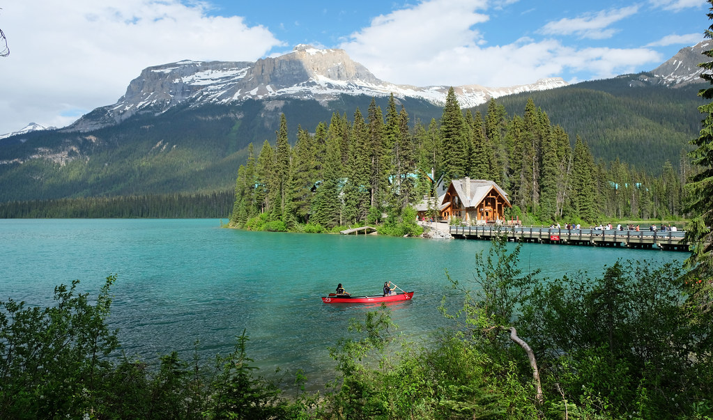
Visit Emerald Lake, the largest and most famous lake in the park, with Mount Burgess and Wapta Mountain in the background. No hiking is needed to reach the lake, but there’s an easy, flat loop trail (~5 km) around it. You can also rent canoes, or stay at the fabulous Emerald Lake Lodge.
The rock formations of Natural Bridge are a short stop on your way to Emerald Lake. Kicking Horse River cascades under the naturally formed stone bridge, snow-capped peaks in the background making the scene postcard-perfect.
30 meters high Wapta Falls is a great family-friendly hike in Yoho National Park.
Sherbrooke Lake is an amazing alpine lake where you’ll surely find solitude. The 3.6 km hike (one-way) starts from the Wapta Lake Picnic Area parking lot.
If you’re looking for solitude, head to the barely known regions and hiking trails in the East and West Kootenays.
Leave a Reply